

JBgeoimage – Applied Spatial Intelligence are celebrating recent successes with the award and delivery of a range of exciting projects around the world. We are also celebrating a combined 140 years of business operations that provides the platform for taking the business from strength to strength in 2019.
The combined businesses offer an in-house technology stack unique to Australasia – everything from traditional construction and cadastral surveying through to 3D scanning and modelling, UAV surveys, aerial photogrammetry, satellite imagery and data analytics. We are the leading provider of spatial services. We focus exclusively on delivering the latest spatial technologies to benefit our clients and their projects.
JBgeoimage has the resources, skills and experience to manage large scale, complex spatial challenges whether they be located in Brisbane or Gold Coast, Pilbara, Africa, Kazakhstan or Greenland. JBgeoimage has the spatial solution.
Our industry sectors include property | construction | infrastructure | mining | agriculture | environment | government.
Jensen Bowers recent project success:
- City of Gold Coast Stormwater Drainage – surveyed for Burchills Engineering and Gold Coast City Council JB provided stormwater infrastructure data to inform flood investigations of the city’s existing stormwater infrastructure and impacts in major storm event.
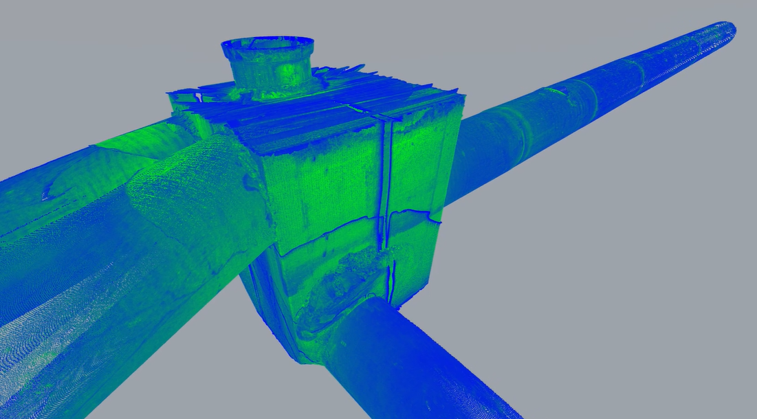
- Aurizon Redbank Rail Yards – 100ha surveyed for Goodman with the latest UAV LiDAR to capture a full colour point cloud of the site and its surrounding areas.
- Gold Coast Airport Terminal Upgrade – awarded surveying & dilapidation services for Lend Lease on this landmark project.
- TMR Ingham Highway Upgrade – awarded survey of 15km of highway using on-ground and UAV technology.
- Mary River Project – engaged by AECOM, Jensen Bowers provided survey data for the Lake MacDonald Upgrade works (3D scanning & BIM modelling)
- Bris1 South Brisbane – completed construction survey for 3 high-rise towers constructed by Hutchinson for Developer R & F Properties.
- South City Square Stage 3, Woolloongabba – This stage of the mixed use project for Pellicano is nearing completion. Volumetric and Building Format Plans will soon be lodged for plan sealing with BCC.
City of Gold Coast Stormwater Drainage

Aurizon Rail Yard
Geoimage recent project success:
-
- Greenland Mining Exploration – supplied archived satellite imagery over 1300sqkm.
- Bribie Island Environmental Study – supplied fresh satellite imagery and completed 500sqkm 4 band spectral analysis.
- Peru Mine Planning – supplied fresh capture satellite imagery and completed 50cm DEM and SWIR analytics.
- Burkina Faso Mine Exploration – supplied fresh capture satellite imagery and completed SWIR analytics.
- Pilbara Riparian Vegetation Study – supplied fresh capture satellite imagery and vegetation monitoring 3rd year.
- Ivory Coast Mine Planning – supplied fresh capture satellite imagery and completed 1m DEM
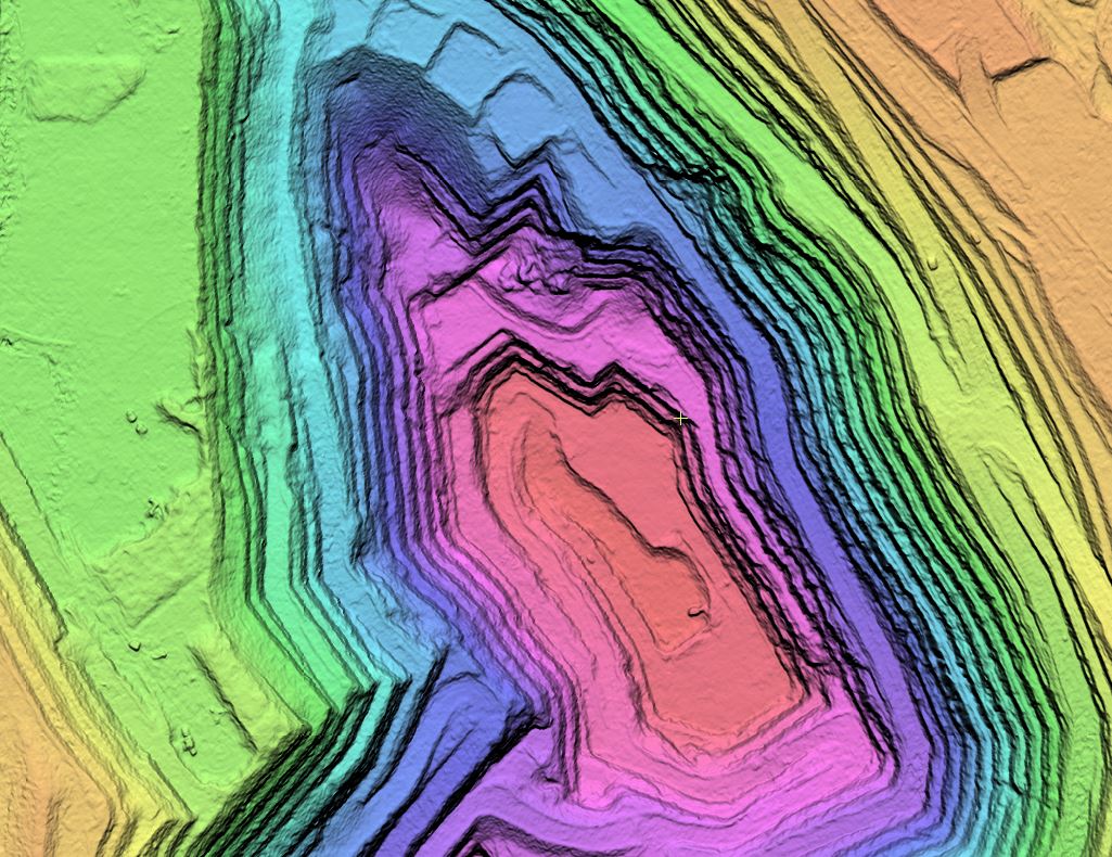
Hi Resolution Digital Elevation Model (DEM) Kalgoorlie Super Pit
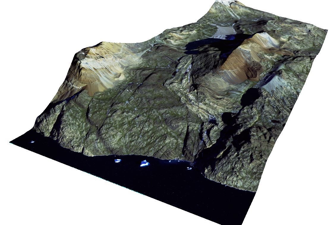
Worldview-3 30cm Imagery Draped over the 30cm DSM – Greenland